Update and Forecast for Dixie Fire, Bootleg Fire, and Tamarack Fire |

|
|
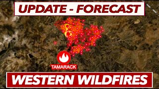
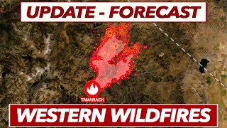
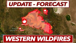
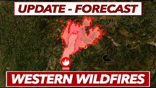
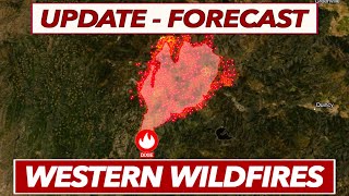
The Dixie Fire, Bootleg Fire, and Tamarack Fire all continue to burn in the West. The most active behavior right now appears to be over the Dixie Fire, which has grown to 103,000 acres. The Tamarack Fire has officially crossed the state line into Nevada, and continues to see tricky conditions with steep terrain and exceptionally dry fuels. Due to a recent spot fire, the Tamarack has now crossed Highway 395, and the overall fire is now over 50,000 acres.The Bootleg Fire combined with the Log Fire and stands at 400,000 acres. Although the Bootleg had previously seen reduced spread rates over the last few days, the smoke on the satellite imagery appears to be picking up this afternoon.
Throughout this video, we'll look at all the important updates, as well as the fire weather forecast to predict how all these wildfires may change in the coming days. You can subscribe to stay updated on all major wildfires throughout the 2021 season. I hope this video was helpful, and thanks for watching. You can also check out my Twitter page where I post more consistent/concise updates on the current wildfires: https://twitter.com/HoltHanleyWX Update and Forecast for Dixie Fire, Bootleg Fire, and Tamarack Fire - Chapters: 0:00 = Overview of Dixie Fire, Bootleg Fire, and Tamarack Fire 2:24 = Dixie Fire Update/Forecast 18:01 = Bootleg Fire Update/Forecast 26:39 = Tamarack Fire Update/Forecast 37:31 = Critically Dry Fuels Explained 40:11 = Summary of Western Wildfires You can obtain the latest information by going to: https://www.facebook.com/plumascountysheriff https://www.facebook.com/BootlegFireInfo/ https://inciweb.nwcg.gov/incident/7674/ https://www.weather.gov https://www.fire.ca.gov https://inciweb.nwcg.gov https://www.windy.com https://gispub.epa.gov/airnow/ You can find Evacuation Maps here: Bootleg Fire: https://kcgis.maps.arcgis.com/apps/webappviewer/index.html?id=4bfb02b41eb7473ca95b04c3cbd1da21 Dixie Fire: https://buttecountygis.maps.arcgis.com/apps/webappviewer/index.html?id=9c92e0a2d2e0415fa5248d70cd644a82&fbclid=IwAR3zQDMa5Sr2VsdqJhPEVK-cBF65Tk7I3DWkq1emeLpBoIaVIHlgPAg8wvE Tamarack Fire: https://inciweb.nwcg.gov/incident/article/7674/61406/ **Note: I'm not sure how often they update these maps or if it is in fact the best one to look at, so be sure to check with local authorities for the most recent information** #DixieFire #TamarackFire #BootlegFire #wildfire #wildfires #CaliforniaWildfires #FireWeather |