♫musicjinni

Drone flight documents dramatic expansion of Kilauea’s crater

video thumbnail
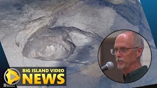
A UAS (Unoccupied Aircraft Systems) mission on June 24, 2018, filmed details of the dramatic changes occurring within Halema‘uma‘u crater at Kilauea’s summit in Hawaii Volcanoes National Park since explosive eruptions of ash and gas and ongoing wall collapse began in mid-May.

Clearly visible are the steep crater walls that continue to slump inward and downward, with ongoing subsidence at Kilauea’s summit. The deepest part of Halema‘uma‘u is now more than 1,300 feet below the caldera floor.

There are two obvious flat surfaces within the crater that have slumped downward as nearly intact blocks — the shallower one is the former caldera floor, and the deeper one is the former Halema‘uma‘u crater floor.

Limited UAS flights into this hazardous area are conducted with permission and coordination the national park. The overflights collect visual information on what is happening at this rapidly changing eruption site. Scientists examine the footage in detail to understand how the expanding collapse area is evolving, the extent of tephra fall, and other surface changes. This information is used to assess hazards at Kilauea’s summit.

Video by the U.S. Geological Survey and Office of Aviation Services, Department of the Interior, with support from the Hawaiian Volcano Observatory and Hawaii Volcanoes National Park.

USGS HVO on summit explosions

USGS Update On Hawaii Eruption - Pahoa Meeting 1/3 (July 24, 2018)

Hawaiian Volcano Observatory (USGS) Presentation Highlights: Science of the 2018 Eruption

Hawaii Volcano Eruption - 11 am USGS Conference Call (Jun. 5, 2018)

Hawaii's Kilauea Volcano - Behind the News

USGS: Hawaii Eruption Unprecedented In Past 200 Years (July 17, 2018)

USGS Status Update of Kīlauea Volcano - May 14, 2018

Kīlauea Eruption Recap - First 6 Hours, December 20, 2020

Hawaii Eruption: USGS Talks Recent Volcanic Events (May 29, 2018)

Kīlauea Video Brief: New Eruption Filling Summit Crater

USGS scientists relocate to UH Hilo as summit explosions continue

Kilauea Eruption Activity Update (Feb. 17, 2021)

Hawaii Kilauea Volcano Eruption USGS 2018 Lava Flow Map Progression 5/4-7/30/2018

HAWAII KILAUEA ERUPTION: USGS Eruption Report 🌋 (July 23,2018)

Hawaii Eruption: USGS Maps Active Fissures, Lava (May 23, 2018)

USGS Hawaiian Volcano Observatory status of Kilauea volcano in Hawaii on May 22, 2018.

USGS Kilauea volcano update, June 14, 2018

USGS Status Update of Kīlauea Volcano - May 23, 2018

Hawaii Eruption: USGS Conference Call (May 24, 2018)

HAWAII VOLCANO Kilauea 🌋 USGS Scary FUTURE of KILAUEA "Tūtū Pele" 7/8/2018

Hawaii Eruption: USGS Conference Call (July 12, 2018)

FUTURE of HAWAII KILAUEA VOLCANO Eruptions by USGS

How the USGS used Drones or sUAS in the 2018 Hawaii Kilauea Volcano Eruption

Kilauea Lava recent update USGS.

Hawaii Kilauea Volcano Now Spewing LAVA BALLS - latest USGS warning

Hawaii volcano eruption reaches 30 years (Jan. 2013)

HAWAII KILAUEA ERUPTION: USGS says" it could last Months To Years! 🌋

Hawaii Volcanoes National Park remains closed amid increased seismic activity

USGS Kilauea volcano update, June 1, 2018

VIDEO: USGS Kilauea volcano update, June 2, 2018

Disclaimer DMCA