How Maps and Apps Are Helping Police Help the Homeless |

|
|
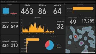
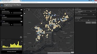
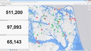
In this month's webinar, join the Esri Law Enforcement Team and San Bernardino Sheriff's Department (SBSD) as we discuss how ArcGIS apps can help your agency have a positive impact on homelessness in the community. With mobile data collection and survey tools it is easy to collect, manage, visualize, and understand data about the homeless population including contacts and encampments. This information can then be shared with other agencies and stakeholders via maps and dashboards in a secure environment. These apps have proven effective tools for the SBSD Homeless Outreach and Proactive Enforcement (HOPE) Team to help the county's homeless population access all of the resources available to them.
For more information, visit www.esri.com/publicsafety |