♫musicjinni

The Next Generation of Hydrography

video thumbnail
Check out video at at https://www.usgs.gov/media/videos/next-generation-hydrography.

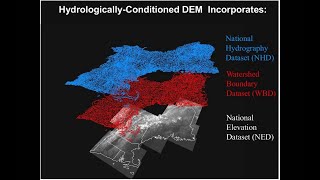
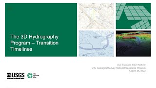
Topic: The Next Generation of Hydrography
Date: August 24, 2021

Presenters: Becci Anderson and Al Rea

The USGS is developing the 3D Hydrography Program (3DHP) as the surface water mapping component of the new 3D National Topography Model (3DNTM.) The 3DNTM is the next generation of the 3D Elevation Program (3DEP) and National Hydrography Datasets, and includes high-resolution elevation, inland bathymetry, hydrography derived from elevation, and connections to groundwater and engineered hydrologic systems. The 3DHP will provide critical data related to flood forecasting and response, agricultural planning, infrastructure design, fisheries and stream ecology research and management, water quality studies, and other emerging applications.

This presentation will provide an overview of 3DHP plans including scope and timelines for the emerging program.

Links:
Kootenai River Topobathymetric Lidar Validation Survey Data - ScienceBase-Catalog: https://www.sciencebase.gov/catalog/item/6009ccf0d34e162231fb238b

Elevation-Derived Hydrography Specifications (usgs.gov): https://www.usgs.gov/core-science-systems/ngp/ss/elevation-derived-hydrography-specifications

Probability of Streamflow Permanence (PROSPER) (usgs.gov): https://www.usgs.gov/centers/wy-mt-water/science/probability-streamflow-permanence-prosper?qt-science_center_objects=0#qt-science_center_objects

USGS Hydrography Webinar Series

What’s Happening with National Hydrography – USGS at AWRA Geospatial Water Tech Conference May 2022

Apr 9, 2015: Hydrography Webinar Series - Session 1

Jul 30, 2015: Hydrography Webinar Series - Session 3

Nov 5, 2015: Hydrography Webinar Series - Session 5

April 2023 USGS Hydrography Community Call

May 21, 2015: Hydrography Webinar Series - Session 2

Mar 17, 2016: Hydrography Webinar Series - Session 7

Understanding the Transition from NHDPlus HR to 3DHP

USGS Elevation Derived Hydrography Specifications and Capture Conditions

OGC API Processes for USGS Water Data

Strategies for improving the Washington State Hydrography Dataset (WASHD)

3D Hydrography Program Transition Timelines

The 3D Hydrography Program – transition status July 25, 2023

April 28, 2020: Elevation-derived Hydrography Acquisition Specifications and READ Rules

Seismic vs hydrologic triggering of landslide dams in the Oregon Coast Range

The Next Generation of Hydrography

Mar 31, 2020: The National Hydrographic Infrastructure (NHI) and Hydrolink Tool

The Latest Updates to the HydroAdd Tool

Hydrography Downloadable Data GeoPackage Format

Updating NHD Infrastructure with Elevation Derived Hydrography—Alaska

Changes to NHD & WBD Data Model and Downloadable Hydrography Products

Webinar: Desert LCC National Hydrography Dataset Project

USGS National Hydrography Database

Watershed Boundary Dataset (WBD) Transitioning to 3DHP

Feb 26, 2019: Chesapeake Bay Elevation-derived Hydrography

Temporal changes in rainfall intensity-duration thresholds debris flows in recovering burned area

Webinar: The StreamStats Web Application of the U.S. Geological Survey

Importance of Monitoring During Extreme Events: Webinar by Bob Hirsch, USGS

MAGIC Webinar: USGS 3D Elevation Program

Disclaimer DMCA