♫musicjinni

World Atlas collection 1880-1924 Historical Geography nice lot of 4 antique books w/ 100's of maps

video thumbnail
[Geographies, Illustrated World Atlases, Education, scholarly geography].

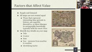
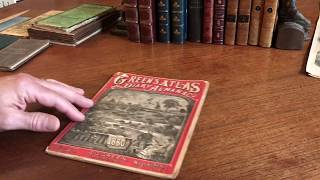
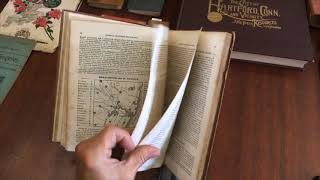
Short video captures condition much better than words. Please watch prior to purchase to ensure a clear understanding of the collection.

Lot of four atlases, each with a different approach. All reference / educational in nature. All in original period cloth bindings, all apparently complete. Great range of cartography and map images, capturing different color printing and book-binding methodologies as well.

Profusion of color maps and pictorial illustrations throughout.

Among the most extensively and colorfully illustrated books of the era, atlases have always been desirable and (often) expensive items.

The Student's Atlas of Ancient & Modern Geography, edited by William Hughes. c.1880's, London by Society for the Promoting Christian Knowledge.
40 double page color lithographed maps with extensive appendix.

Harper's School Geography with Maps and Illustrations Preprared Expressly for This Work by Eminent American Artists.
Published 1894, New York by American Book Company.
28 plates with numerous engravings. Pictorial globes cover.

Historical Atlas, by William R. Shepherd.
Published 1924, New York by Henry Holt and Company.
216 color lithographed map plates with large detailed index.

1923 Atlas of the World and Gazetteer.
Published 1923, New York by Funk and Wagnalls.
170 pages, many color maps including all individual U.S. states.

Set along the shelf measures: 4".
Largest book measures: 12 1/2" H X 10 1/4" W.
Smallest book measures: 9 1/2" H X 6 1/2" W.

[V1918].

Like and Subscribe for more updates on our ever-growing collection of fine maps, prints, and books.

Available at: https://antiquemapsprints.com/collections/video-collections/products/world-atlas-collection-1880-1924-historical-geography-lot-x-4-books-100s-maps?variant=30364040364110

World Atlas collection 1880-1924 Historical Geography nice lot of 4 antique books w/ 100's of maps

I Will Show You How To Find Antique Maps Worth Good Money In Old Books.

V & J Duncan Antique Maps, Prints and Books

"What’s My Map Worth? How to Value Antique Maps” by Eliane Dotson

Collecting Old Maps A MUST HAVE for those interested in Antique Maps

American Gazetteer 1797 Jedidiah Morse 7 rare maps | Brian DiMambro Virtual Book Tour

Prints Old and Rare - Pacifica California

THIS JUST IN No. 3: Caribbean prints and maps

SOLD - Teacher - Antique Junk Journal Flip Through by Hyperstamper

New England map 1809 J. Morse rare old history book complete Parish

rare Book Box 18th century secret compartment mid-1700's pair old books

Amos Doolittle rare old engraved maps & Astronomy print

The International Antiquarian Book Fair: Rare Books Never Get Old #antique #rarebooks #collector

FOUND - Goya Prints Worth $617,000 Hidden in Old Book

Paris Exposition Universelle 1867 rare old pocket map folding detailed

Texas 1880 rare Boschee's German Syrup medicine old map Green's Almanac

Antique Maps from A Royal Atlas, Rare Maps and Prints Review Episode 4

Murray Hudson - Antiquarian, Books, Maps, Prints, & Globes: Mississippi

Kevin Brown, Geographicus Rare Antique Maps

My Rare, Old & Antique Books

United States 1851-3 rare large old territorial map Mormon settlement shown

Paul and Virginia 1795 Mauritius Isle de France 2 old rare books 1824

George Washington 1796 Farewell Address London Universal rare old book

American Atlas & Geography Book 1833 Blake and Hazen Morse w/ 12 color maps rare book complete

Jedidiah Morse 1807 Geography old leather book w/ world North America maps

Chapbooks 1820-50's lot of 10 rare old children's books w/ woodcuts

Sale 534: Fine & Rare Books - Asian & Graphic Art - Maps

RARE BOOK MOMENT 2.0 -- No. 1: The vocabulary of book collecting

European engraving antique prints 1846-79 Lot x 3 nice books Duplessis France Hymans Rubens Gavarni

History of Engraving in France 1861 duPlessis old book uncut

Disclaimer DMCA