California's Lithium Valley and Induced Seismicity |

|
|
Join us in this video as we visit Lithium Valley located at the intersection of the south end of the Salton Sea with the north end of the Imperial Valley in Southern California. Federal, state, and local agencies are teaming up with industry in pursuit of a vision of proving up new technologies and environmental protections to make California a world leader in sustainably coproducing lithium with renewable electricity from geothermal plants. We compare some interesting geologic features in the area with historic reports. Additional discussion includes geothermal operations, induced seismicity, and lithium extraction.
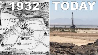
Chapters: Governor Gavin Newson’s vision for Lithium Valley: 00:20 – 00:55 Lithium Valley Specific Plan and local planning workshops: 00:56 – 1:05 Southern California location map: 1:06 – 1:26 Map of major faults, Salton Buttes, and Salton Sea Geothermal Field: 1:26 – 2:12 Highway 111 closure and detour around the Niland Geyser: 2:35 – 3:12 Niland Geyser migration over 2008 – 2020 and railroad rerouting: 3:13 – 4:14 Water and gas bubbling up from the Niland Geyser: 4:15 – 5:00 Attempts to halt migration of the Niland Geyser: 5:01 – 5:48 Niland Geyser location within the Wister mud pot lineament: 5:49 – 6:42 1869 map shows mud volcanoes: 6:43 – 7:11 1889 map shows Volcano Springs train stop at Niland Geyser location: 7:12 – 7:44 1901 article reports large oil well blowout at Niland Geyser location: 7:45 – 8:03 Map showing 1905 flood that created Salton Sea: 8:04 – 8:33 Volcano Springs disappears into the Salton Sea: 8:34 – 9:08 Niland replaces Volcano Springs as local place name: 9:09 – 9:38 Map shows Volcano Springs within Wister mud pot lineament: 9:39 – 9:58 1918 map shows receded Salton Sea, mud volcanoes, and Salton Buttes: 9:59 – 10:16 Brawley Seismic Zone, volcanics, and geothermal heat: 10:17 – 10:50 California State Mineralogists severely burned in mud volcano: 10:51 – 11:10 1927 travel map showing mud volcanoes as a tourist destination: 11:11 – 11:29 Calipatria fault aligned with mud volcanoes: 11:30 – 12:34 1930’s – 1940’s Imperial Carbon Dioxide Gas Field development: 12:35 – 13:55 1933 carbon dioxide well blowout at location of Niland Geyser: 13:56 – 14:24 Dry ice plant ruins and craters around old carbon dioxide wells: 14:25 – 15:17 Salt mining in the 1800’s: 15:18 – 15:45 Geology map showing faults and volcanic rock: 15:46 – 16:02 USGS volcanic hazards map showing Salton Buttes: 16:03 – 16:43 Geothermal drilling rig viewed from Obsidian Buttes: 16:44 – 17:08 Geothermal industry standards and project types: 17:09 – 20:03 Induced seismicity caused by injection operations: 20:05 – 20:44 Mitigation of induced seismicity in Texas: 20:45 – 21:12 Induced seismicity in the Salton Sea Geothermal Field: 21:13 – 22:34 Lithium extraction methods: 22:35 – 25:10 Waste brine and geothermal operations in Mexico: 25:11 – 26:00 Business Inquiries: Californiawhistlestop@gmail.com |