DAY OF THE TWINS - Tornado terror in Nebraska |

|
|
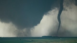
The Pilger Twin EF-4 tornadoes, The Wayne County line satellite and birth of the Wakefield EF-4 tornado. Full story w/ radar and commentary. To license HD tornado video contact hankschyma@yahoo.com
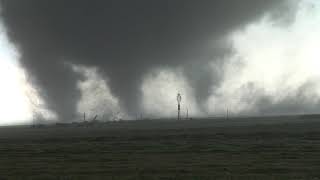
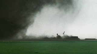
THE EVENT: June 16, 2014 Early this afternoon the Storm Prediction Center was monitoring a volatile atmosphere over Nebraska. By 2:34 PM satellite imagery revealed a lone thunderstorm developing in Boone, Platte and Madison counties and By 4PM a large damaging tornado was being reported near the town of Stanton. Base velocity started revealing a second area of powerful rotation within the storm. The Stanton tornado would earn an EF-4 rating before dissipating Near highway 57 and 275. When I arrived at the scene, another tornado had developed southwest of Pilger, NE and strengthened to EF-4 status while striking the small town killing 2 people and critically injuring around 20 others. During this time a 2nd tornado was developing to the southeast. This tornado would become the eastern twin and would also strengthen to an EF-4. The tornado that struck Pilger (the western twin) weakened shortly after crossing highway 275 and the condensation funnel completely lifted for several minutes while dust continued to whirl on the ground. At this time the Eastern twin was growing wider. Condensation funnels started to drop from the western mesocyclone and twins were again on the ground growing in size and closer together. The eastern twin was arcing to the north while the western twin tracked more northeast. Their damage paths would eventually cross about 5 miles northeast of Pilger or 5 miles northwest of Wisner. From my perspective the twin tornadoes vanished behind a rainy mass and another mesocyclone would develop just to the east and drop the soon to be Wakefield EF-4 tornado. Curtains of rain cleared in the rainy mass revealing a thick tube that would crawl easterly along or near the Wayne County line. This tornado became the rope satellite that would slingshot around the southern flank of the developing Wakefield tornado. The Wakefield tornado tracked almost due north and dissipated to the east of Wakefiled. After the Wakefield tornado moved into the rain and dissipated, a new mesocyclone developed to the east or southeast continuing the double helix mesocyclone development pattern of the day. The storm was now thinning and displaying a long twisted updraft. This updraft would threaten with several bowl funnel clouds with weak rotation confirmed on the ground on two seperate occasions by storm chaser Aaron Rigsby before dropping the finally brief weak Hubbard "scuddy" tornado. This storm weakened drastically as it crossed into Iowa near Sioux City. more later... |